


The research of the Geodynamics Group can be categorized into three areas: (i) the modelling of the dynamics of lithospheric deformation during tectonic events and the interface between these models and geological observations, (ii) the geodetic monitoring of Earth surface deformation and the constraints imposed by these data on the tectonic models, and (iii) the modelling of past sea-level change and the implications of these variations on the Earth's rheology, on the past ice sheets, on vertical rates of tectonic movements, and on the evolution of coastlines. These three areas have the common thread of understanding the processes that have shaped the Earth's crust and lithosphere by linking geologic and geodetic field observations to geophysical models via laboratory measurements and experiments.
One example of laboratory experiments conducted in 1996 is the analog modelling of continental collision at a plate margin by honours student Mr D. Burbidge. This experiment provides a mechanical verification of numerical models developed earlier by Dr J. Braun and gives insights into the evolution of the crust at plate margins such as that through the South Island of New Zealand of which the Southern Alps are the most visible manifestation. Geological and laboratory work by a doctoral student Mr G. Batt, provides further field and laboratory constraints in terms of the rates of vertical movements and thermal evolution of the crust as the Pacific and Australian plates come together at this margin.
In Papua New Guinea, crustal deformation resulting from the convergence of the Australian and Pacific Plates forms the laboratory for observing tectonic processes and these are being monitored, through a cooperative program with PNG institutions, using modern geodetic methods. Geological and geomorphological observations complement these experiments. This program, led by Dr P. Tregoning, is providing the first reliable estimates of the relative motions of the fragments of crust at the margin of the two super-plates.
The study of sea-level change is also an area of interaction between field-laboratory and theoretical work. New results are emerging from work by doctoral student Mr Y. Yokoyama on sea levels in late glacial times in northwestern Australia and this, combined with glacio-hydro-isostatic models, is providing new results on the morphology of the shelf area, including the Bonaparte Gulf, over the past 20,000 or so years. Results for the emergence of the Antarctic margin from a larger-than-present past ice load have been reported in earlier annual reports for the Vestfold Hills and new results are in preparation for the Bunger Hills area. Later this year Dr D. Zwartz will begin a fieldwork project with the Japanese Antarctic Research Expedition in the Rüser-Larsen, Enderby Land, area to quantify the rebound there. Recently arrived doctoral student Ms J. Quinn will carry out similar work in Victoria Land also later this year in cooperation with the New Zealand Antarctic Program and Victoria University of Wellington, New Zealand. It is expected that the combination of the field measurements of rebound and ice retreat, the latter in cooperation with Dr J. Stone of the Environmental Geochemistry Group, with modelling of the isostatic rebound will provide major constraints on the past changes in the Antarctic ice sheet.
A new initiative started in the group this year is the monitoring of temporal changes in gravity through a cooperative project with the National Astronomical Observatory (NAO), Mizusawa, Japan. A super conducting gravimeter, capable of measuring changes in gravity at the level of 10-9 cm sec-2 with long-term stability, has been provided by NAO and this will be combined with periodic absolute gravity measurements to provide a long-period record of changes in gravity.
This year Dr G. Kaufmann joined the group from the University of Münster, Germany, initially as an ARC International Fellowship and extended for a further two years on a Deutsche Forschungsgemeinschaft Postdoctoral Fellowship. Dr D. Zwartz successfully defended his thesis and, after a summer season in Antarctica and some time in Japan, rejoined the group as a temporary staff member. Ms C. Stirling submitted her thesis this year on sea-level change and the chronology of the last (and earlier) interglacials. Dr G. Bassi joined the group during the year and also taught the geophysics course in the Geology Department.
SEA-LEVEL CHANGE, MANTLE VISCOSITY, ICE SHEETS AND SHORELINE EVOLUTION
The primary objective of this research program is to understand past and present sea-level change associated with past glaciation and deglaciation cycles. A complete formulation of this change permits the following issues to be addressed: (i) properties of the Earth's rheology (its viscosity), (ii) properties of the ice sheets (ice volumes and the timing of onset or termination of glaciation), (iii) the establishment of a reference sea-level surface for quantifying vertical tectonic movements, (iv) the evolution of shorelines and the impact of the migrating shorelines on movements of Palaeolithic man, (v) evolution of crustal stress fields beneath the former ice sheets, (iv) changes in the global inertia tensor of the Earth and consequences on the Earth's rotation and motions of earth-orbiting satellites, (vii) evaluation of present-day sea level and the separation of the geological signal from signals produced by recent climate change.
All these aspect are under investigation within the group's program and some of these are discussed in the following sections Reports on some of the other on-going projects can be found in past School Reports.
Sea-level change during the last 40,000 years
Y. Yokoyama, K. Lambeck, P. De Deckker[1], T. Esat and J. Marshall[2]
The maximum sea-level fall during the Last Glacial Maximum (LGM) is an important quantity for constraining the total land-based ice volumes at that time. Yet this quantity remains poorly constrained. The locations and depths of past shorelines can be best determined from observations at tectonically stable margins far from the former ice caps so that glacio-hydro-isostatic effects are relatively small and not strongly dependent on detailed assumptions about the ice sheet and melting histories. The best records are the height-age relations of sediments in which the marine transgression can be identified. The Northwest Shelf, including the Bonaparte Gulf, provides a good setting where records of past shorelines may be preserved in the sedimentary record of the shallow areas, in water depths less than about 150 m.
A second problem associated with the LGM and the lead up to it is the timing of this event and the time-scale used. The radio-carbon time scale is known to diverge nearly uniformly from the uranium-series time scale or dendrological or varve time scales that reflect sidereal time. But the trend beyond about 20,000 years remains poorly constrained. Also, the carbon ages of corals and other carbonates become increasingly unreliable after about 20,000 years. In consequence, the history of the ice growth leading up to the LGM remains poorly constrained and this is of some consequence in the modelling of sea-level change after this time. The oxygen isotope records from deep sea cores provide some constraints on the oscillations in sea-level change but only by making assumptions about time scales, uniformity of sediment deposition rates and about the relationship with 18O changes and sea level change. Independent estimates of sea-levels for the pre-LGM period therefore provide a means of improving the calibration of the oxygen isotope curves.
Several interrelated projects have been initiated this year. Gravity core samples have been recovered from the Joseph Bonaparte Gulf and the Timor Sea to the northwest of Australia through projects involving the AGSO ship "Rig-Seismic" and the CSIRO ship "Franklin". Some 70 cores have been examined for sedimentary facies, including foraminifera, ostracods, and diatoms, and for palaeoenvironment, including water depths. Transitions from terrestrial or lacustrine conditions to full marine conditions have been identified in a number of the cores in water depths between 120-130 m. Samples have been prepared for accelerator mass spectrometry dating (AMS).
To minimize contamination of samples during the pre-treatment process for AMS dating, a new clean CO2 extraction and carbon combustion vacuum line has been constructed for analysis of pre-LGM materials, mainly corals form the coral reef II and III complexes of the Huon Peninsula, Papua New Guinea. These reefs have previously been dated to between 29,000 and 54,000 14C years BP. Mass spectrometric U-series age determinations are also in preparation using the improved methods discussed by Stirling et al. in the 1995 Annual Report (p. 33-35).
Lateglacial and Holocene eustatic sea-level change
K. Fleming and K. Lambeck
This work is similar to that reported in the previous section except that it concentrates on the sea-level change since the time of the Last Glacial Maximum (LGM). Some key questions are the rates of melting of the land-based ice sheets, the magnitudes of the ice volumes, and the time of termination of melting of the major ice sheets. Records of coral ages versus depth from single localities provide a measure of the growth of the reef and sea levels must have been

Figure 1: Eustatic residuals for the data from western Africa, mainly the Senegal River area. The eustatic up and eustatic down symbols represent points where all that could be said was that the eustatic curve would have been above or below that value. The solid line is the nominal eustatic curve of the ice model used in these calculations in which all melting ceases at 6000 years BP. As can be seen, there is some 3-5 metres variance between the model's eustatic curve and that resulting from the field data.
above these corals. Also, the present-day depths need to be corrected for glacio-hydro-isostatic factors in order to reduce them to eustatic sea level. Earlier studies have examined the evidence from the Australasian region and recent work has focused on other tectonically stable areas of the world. A persistent conclusion from the observational evidence of sea-level positions for the past 7000 or so years is that ocean volumes continued to increase after 6000 years BP. Small amplitude highstands are predicted and observed to occur at this time along continental margins and at some islands due to the glacio-hydro-isostatic effects and the amplitudes are functions of the Earth's rheological parameters and any residual melting of the ice sheets at that time. Some separation of parameters is possible by looking at the spatial variation in the highstands, both along and across coastlines, and such studies point persistently to a need to increase ocean volumes during Late Holocene time. Figure 1 illustrates results for western Africa, and similar results have been obtained for the French Atlantic coast, the Caribbean region, south eastern Asia, and the Australian margin.
Holocene sea-level change and ice sheet history in the Bunger Hills, Antarctica
D. Zwartz, J. Stone and K. Lambeck
In a continuation of work to determine the history of the Antarctic ice sheet during the last glacial cycle (see 1995 annual report), field work was conducted in the Bunger Hills as part of the Australian National Antarctic Research Expedition (ANARE). The Bunger Hills Oasis is a region of low hills on the edge of the East Antarctic ice sheet, at 66deg.15' S, 101deg. E. The region of exposed rock is about 20 30 km, with abundant lakes and marine inlets.
Previous observations of raised beaches in the Bunger Hills demonstrated that sea-level in this region has fallen over the past few thousand years by at least 8 meters. However, the Antarctic beach ridges are difficult to date, because they contain little or no in-situ organic material. Also their relationship to mean sea level is poorly understood. In the current work, lakes were identified in basins with low-lying sills connecting them to the sea. When sea-level was higher, such basins may have been joined to the sea, becoming isolated as sea-level fell below the sill level. Sediment cores were collected from these lakes, and in two cases a transition from marine to lake sediments was observed in the core. Radiocarbon dating of these transitions allows a more precise sea-level history to be determined.
That the Antarctic ice sheet once completely covered the Bunger Hills is evident from the glacial striations, moraines and erratic boulders which are found throughout the region. Numerous erratic boulders and samples of striated bedrock were collected for exposure age dating using cosmogenic isotopes (chlorine and aluminium). These ages should define the last retreat of the ice sheet across the Hills. Samples were also collected from several other outcrops within 100 km of the Bunger Hills, to determine the extent of the last expansion of the ice sheet over a wide region. The ice retreat history obtained from this work, together with similar results for the Vestfold Hills and anticipated results for Victoria Land, and the estimates of relative sea-level change, provide key inputs into the modelling of the ice sheet for the last glacial cycle.
The Bunger Hills field work was conducted in collaboration with Drs D. Gore (Macquarie University) and P. Augustinus (University of Auckland, New Zealand), who are using other geomorphological and dating techniques to approach the problem of recent ice sheet history.
Glacial isostatic adjustment in Scandinavia
K. Lambeck, C. Smither and P. Johnston
The Scandinavian region remains one of the best documented regions of crustal rebound in response to the glacial unloading that started at about 18,000 years ago and ended about 9000 years later. Because of the viscous response of the Earth to changes in its stress state, this rebound is still going on. The rates, amplitudes, and spatial and temporal variations of the rebound recorded in the geological record of the past 12,000 or so years provide valuable constraints on both the Earth's viscosity and on the history of the Scandinavian ice sheet.
Observational data for the region has been compiled and evaluated, including field examination of some of the key sites, and a new data base of some 800 age-height relationships of past shoreline positions established. This data, combined with "standard" ice models, has been inverted for the Earth's viscosity structure. Principal outcomes include: (i) The effective lithospheric thickness is about 60-80 km, the effective average upper mantle viscosity, down to the 670 km phase boundary, is about (3-4)1020 Pa s, and the effective average lower mantle viscosity exceeds about 1022 Pa s. (ii) No major lateral variations in these parameters occurs across Scandinavia and Finland. (iii) The maximum ice thickness at the time of maximum glaciation is of the order 2500 m but the ice sheet over the eastern region is much less than in the conventional models with parabolic ice-height profiles (Figure 2). Ice heights over the continental margin of Norway also do not appear to follow the conventional profiles. The mantle rheology parameters are comparable to those found for other parts of the world (see the 1994 Annual Report) but the preliminary constraints on the ice sheet model points to a need to make major changes in the model for ice sheet decay.
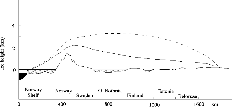
Figure 2: Profile of the proposed ice sheet over Scandinavia from the Norwegian Shelf in the west, to the Gulf of Bothnia, Finland and Beloruse in the southeast. The dashed line shows the profile from the model by Denton and Hughes.
Glacial isostatic adjustment in the Barents Sea
G. Kaufmann
The Barents Sea region is important in the study of sea-level change because while the region was glaciated during the last ice age, the extent of the ice sheet remains poorly known. Observational evidence of raised shorelines, up to 100 m above present sea level, points to there having been substantial ice cover over at least parts of the region and such observations can be used to place constraints on the ice sheet (see 1993 Annual Report). Such studies pre-suppose a knowledge of the mantle viscosity and assume that any lateral variation in the viscosity is unimportant. However, the western margin of the Barents ice sheet on the continental shelf lies close to the Arctic Ridge where lithospheric and upper mantle parameters can be expected to differ from those for the continental structure of the Barents Sea itself.
In a collaborative study with Professor P. Wu, (The University of Calgary, Canada) and Dr D. Wolf, (Geo-Forschungs Zentrum, Potsdam, Germany), the effects of lateral heterogeneity in the mantle on predictions of rebound has been examined using a finite-element code and different scenarios of lateral structure across the continental margin. The results show that lateral heterogeneities significantly influence predictions of sea-level change, and that observations in the vicinity of the formerly glaciated areas are particularly sensitive to lateral variations in the Earth's mantle. However, predictions for such sites are also very dependent on a detailed model of the ice sheets across the margins, just where most ice sheets are poorly known. Future high precision models for glacial rebound will need to consider the effects of such lateral variations.
Numerical modelling of glacial rebound phenomena
P. Johnston and K. Lambeck
The Holocene and present sea-level record show that the Earth continues to change shape in response to the melting of the Late Pleistocene ice sheets. Ongoing deformation of the Earth changes the mass distribution within the Earth and consequently the Earth's gravity field. The Earth's hydrological system (oceans, lakes, ice sheets and groundwater) is another source of large scale mass redistribution at the Earth's surface, and therefore also affects the gravitational field of the Earth.
Satellites orbiting the Earth are subject to its gravity field and by observing their motion, it is possible to measure the shape of the equipotential surface (geoid) relative to a reference ellipsoid. With over 20 years of observations, it is now possible to determine precisely the rate of change of the longest wavelength component of the geoid. Models have been developed to predict the glacial rebound component of the perturbation to the satellite orbit. The effect of present melting of the Antarctic and Greenland ice sheets and mountain glaciers is also calculated. Comparison of the predictions with the observations constrains the present rate of sea-level rise at about 1.5 mm/yr and an average lower mantle viscosity of approximately 1022 Pa s, consistent with analyses from sea-level observations.
The satellite observations alone do not uniquely constrain the average lower mantle viscosity because of the sensitivity of predictions to recent melting of ice sheets. Work is in progress examining the effect of deglaciation on the Earth's polar motion which is also sensitive to deep mantle viscosity, but less sensitive to the present mass balance of ice sheets. Combination of analyses of polar motion, satellite orbit data and sea-level data will provide more robust constraints on the present rate of sea-level change and deep mantle viscosity.
MODELLING OF TECTONIC PROCESSES
The main focus of this research is on a better understanding of the dynamics of continental lithospheric deformation during tectonic events such as plate collision or rifting. We do not limit these studies to the continental lithosphere in isolation but consider the complex interactions between the lithosphere, the overlying hydrosphere and atmosphere, and the underlying viscous mantle. The approach is process-based and focuses on case examples that are used as "natural laboratory experiments" to test and validate new ideas. Most of the projects are multi-disciplinary and include theoretical, experimental and observational components.
The emphasis this year has been on two areas of research: the processes of crustal deformation at obliquely convergent margins through a combination of mechanical and numerical modelling with field and laboratory work applied to the Southern Alps of New Zealand, and the evolution of escarpments along passive continental margins such as in southern Africa and southeastern Australia. The mechanical modelling experiments have led to the formulation of an elegant theory that explains the geometry of incipient faulting and the conditions for strain partitioning in transpressional collision zones in terms of simple physical processes. New sampling of the Southern Alps for material for thermo-chronological studies, coupled to a new generation of numerical models is producing exciting new results on the dynamics of plate interaction at convergent plate boundaries.
The theoretical and numerical expertise developed in our group has fostered interactions with other groups in the School. Some of these projects include the modelling of fluid percolation in fractured rocks with Drs Munroe and Cox of the Petrophysics Group and the production of 3D visualization software for the SKIPPY and global seismic wave inversion projects of the Seismology Group. International collaboration continued, with Professor C. Beaumont's Geodynamics Group at Dalhousie University, Canada. Much of the software developed by the group has also been made available to collaborators in various academic and research institutions (University College, London; Massachusetts Institute of Technology, USA; Pennsylvania State University, USA; La Trobe University, Melbourne; Oregon State University, USA; Free University, Amsterdam).
Analog modelling of oblique continental collision at transpressional plate margins
D. Burbidge and J. Braun
Most compressional plate boundaries are characterised by oblique convergence: the velocity vector of relative convergence between the two "colliding" plates is oblique to the strike of the plate boundary. Examples include the Southern Alps in New Zealand and the Coastal Ranges in Southern California. In 1994, J. Braun, in collaboration with C. Beaumont (see p.41 of 1994 Annual Report), used a three-dimensional finite element model of the crust to demonstrate that deformation at obliquely convergent plate boundaries may be accommodated in two distinct ways: (a) in cases where the relative plate movement is dominantly transcurrent, the deformation is partitioned between transcurrent deformation along a set of nearly vertical strike-slip faults and convergence along a separate shallow dipping thrust fault; whereas (b) in cases where the relative plate motion is dominantly convergent, deformation is entirely accommodated by oblique slip along a single thrust-like structure.

Figure 3: Result of an analog experiment. Vertical cross-section normal to the plate boundary after oblique convergence of approximately three times the original sand pack thickness.
We have developed an experimental device to test the results of Braun and Beaumont's work and extend it to large deformation. In our experiments, a 10 cm-thick pack of dry sand is forced, as in the numerical experiment, to shorten by basal traction which represents subduction of the underlying mantle part of the lithosphere. Dry sand is a suitable analog material to study the mechanical behaviour of the brittle part of the Earth's crust. Deformation is driven by two small independent electrical motors which allows us to accurately explore a wide range of relative plate velocities.
The results confirm the predictions of Braun and Beaumont that two modes of deformation, partitioned and non-partitioned, exist, depending on the obliquity of the convergence across the plate boundary. The analog model allowed us to extend these conclusions beyond the limit of small-to-medium strain imposed by current numerical method.
Interpreting the thermo-dynamic development of the Southern Alps of New Zealand
G.E. Batt and J. Braun
The focussed deformation and erosion associated with zones of continental collision often exposes material from a sufficiently great depth such that during its exhumation it cools through the closure temperature for one or more isotopic dating systems. As a result, the young isotopic ages characteristically exposed in active orogens provide a potential means of investigating the sub-surface dynamics.
The interpretation of such data must be accompanied by an important caveat: the high rates of deformation and erosion typical of orogenic belts result in major perturbation of the regional geothermal gradient: thus, the very factor we aim to assess feeds back into, and complicates, the means by which we hope to investigate it.
We have been studying the influence of this dynamic thermal effect on isotopic ages in orogenic regions by using a fully coupled thermo-mechanical model of the deforming crust. Analysing a range of plausible crustal conditions demonstrates that ages exposed in active mountain belts are predominantly cooling ages representing a continuous record of the passage of rocks through the surface thermal boundary layer. Such ages are thus unrelated to any specific causative event.
Cooling related data of this sort is influenced by a wide range of physical and thermal variables, including uplift rate and geometry, geothermal gradient, the mineralogy and crystallography of the mineral species concerned, and the rheology and thermal conductivity of the crustal rocks. Under such conditions, it is not possible to produce a unique forward model to explain each age in isolation. However, as many of the variables listed above are likely to be consistent over extensive areas, investigating isotopic ages over an entire orogen presents a useful indicator of dynamical conditions. This approach is being applied to an analysis of the Southern Alps of New Zealand. By modelling a range of alternative scenarios for this orogen, we are developing an optimal integrated history to explain the variation in character observed along the active collision zone in an internally consistent, mechanistically viable manner. This modelling is constrained by an accumulated body of thermochronological data incorporating K-Ar, Ar-Ar and fission-track dating of various mineral species (see contribution by Batt, McDougall and Braun, this issue), and supported by surface geology, and geophysical and structural information.
Fully coupled thermo-mechanical models of crustal deformation and surface erosion/deposition
J. Braun and P. Fullsack[3]
The movement of lithospheric plates at the surface of the Earth leads to major deformation of the plate boundaries or, sometimes, of their interior. The mantle part of the lithosphere is thought to be of uniform composition and to behave in a quasi-viscous manner. The crust, on the other hand, is compositionally layered and is characterised by a strong temperature gradient; its mechanical behaviour is therefore complex, combining frictional brittle behaviour and thermally-activated creep. Along its surface, the crust is subjected to strong interactions with the hydrosphere and atmosphere via erosion and sedimentation. It is only recently that the full extend of this complex non-linear coupling has been recognised (see p.41 of 1995 Annual Report).
Most geological features, such as sedimentary basins or mountain belts, are the results of large scale tectonic movements. The field geologist relies on a large variety of geological, geophysical and geochemical observations to piece together episodes of the past tectonic history of a given terrane. In the past few years, we have developed a new numerical method, the Dynamic Lagrangian Remeshing (DLR) method, that allows us to solve the problem of large-strain tectonic deformation with great accuracy and efficiency. Recently, we have improved the DLR method to produce forward models of crustal deformation in a variety of tectonic settings and to make predictions that may be directly compared to field observations. These improvements include:
* dynamical mesh refinement in regions of high deformation rate;
* coupling the surface of the crustal model with a geomorphic model that includes mass transport by rivers and diffusion processes;
* coupling the mechanical model with a thermal model that accounts for heat transport by conduction and advection, the temperature being in turn used to define the strength of the rocks;
* compositional and/or density boundaries that may be strongly deformed during episodes of active tectonics;
These improvements have allowed us to make unique predictions on the nature, metamorphic grade and geochronology of rocks at the surface of past and presently active tectonic regions. Specifically, we have studied the Alice Springs Orogeny of central Australia, late Palaeozoic lithospheric extension in the Fitzroy Trough of northern Western Australia and the oblique plate convergence in the Southern Alps, central South Island, New Zealand (see report by Batt and Braun, this issue).
Modelling post-breakup landscape evolution across the eastern margin of South Africa
P.A. van der Beek, J. Braun, R. Brown[4] and M.A. Summerfield[5]
Many rifted continental margins in the world show a conspicuous escarpment which separates a high-elevation interior plateau from a strongly dissected and low-elevation coastal plain. The formation and evolution of such systems not only poses a first-order problem in tectonics and geomorphology, but also has implications for our understanding of sediment sourcing and dispersal in offshore sedimentary basins, as well as climatic evolution on a (sub)continental scale. The eastern margin of South Africa is a classic example of a high-elevation rifted continental margin. Traditionally, the evolution of the margin has been reconstructed by correlating onshore erosion surface remnants with offshore sedimentary sequence boundaries, for instance through the well-known works of L.C. King. Later, attempts have been made to date recognised erosion surfaces using weathering deposits, as well as to derive denudation histories from offshore sedimentation rates. All these approaches, however, faced serious problems of either correlation, quantitative dating control or demarcation of sediment source areas.
Recently, Brown and Summerfield have collected a large amount of apatite fission track data from the Lesotho highlands and the Natal coastal area, in order to better constrain the denudation history of the south-eastern African margin (Figure 4). These data provide evidence for substantial post-breakup cooling and denudation, both to the west and to the east of the Lesotho highlands crest. Seaward of the escarpment, >4 (and possibly up to 7) km of crustal section have been removed since ~100-80 Ma. Inland of the escarpment, the data indicate ~2 km of denudation since ~80-60 Ma. The data are in partial disagreement with traditional models of landscape development in eastern South Africa. For instance, the absence of a younging trend of fission track ages from the coastline towards the escarpment is inconsistent with a classical model of escarpment retreat. Also, the fission track ages inland do not corroborate the ages previously assigned to specific erosion surfaces.

Figure 4: A simplified geological and topographic cross-section across the SE African margin, showing the locations and apatite fission track ages of borehole and outcrop samples. The inferred age and depth of denudation is shown for each borehole and the coastal region. After Brown and Summerfield.
We employ a recently developed numerical surface processes model (see p.43 of 1995 Annual Report) in order to quantitatively assess the controls on landscape evolution and denudation history of the margin. We aim to constrain the relative importance of factors such as antecedent topography, lithological control, evolution of inland drainage and flexural rigidity of the lithosphere on landscape evolution. The model tracks the evolution of topography and the denudation history for each point in the grid. From the modelled denudation histories we predict the pattern of fission track ages across the margin. Modelling results are compared with the present-day margin morphology (e.g., position and elevation of the top of the escarpment, escarpment slope etc.), as well as with the amounts of denudation inferred from the exposed stratigraphy and the fission track data. The predicted amount of post-breakup isostatic uplift, in response to erosion of the margin, is compared to the elevation of remnants of uplifted Cretaceous-Palaeogene marine sediments within the coastal zone.

Figure 5: Modelling results for (a) erosion of an initially flat 3 km-high plateau and (b) erosion of a plateau containing an initial drainage divide 100 km inland from the present-day coastline. The figures show the landform evolution at different times after continental breakup. Note the strikingly different evolution for both models, in spite of the only subtle difference in initial conditions.
Modelling results indicate that the initial (pre-breakup) morphology of the area exerts a key control on the subsequent evolution of the margin (Figure 5). A model in which a pre-existing drainage divide is located 100-150 km W of the present-day coastline gives results that compare best with the observations. It predicts rapid denudation of the entire area seaward of the initial drainage divide during the first 30-50 My after continental breakup, consistent with the denudation histories inferred from the fission track data. Additional first-order controls appear to be exerted by the flexural rigidity of the lithosphere, which directs the amount and distribution of isostatic rebound, and the onset of inland (westward draining) drainage. Best-fitting models are characterised by remarkably low flexural rigidities (Figure 6): they have equivalent elastic thicknesses of the lithosphere on the order of 10 km, which is substantially smaller than elastic thicknesses inferred from other studies of tectonic processes operating on time scales of about 106-107 years and longer. Denudation from the top of the Lesotho highlands appears to have been initiated by an inland drop in base level that occurred at around 80-90 Ma. Although the regional stratigraphy (consisting of a cap of resistant basalts overlying softer Karroo sediments, which in turn overly the hard crystalline basement) has strongly influenced the morphology in detail, the models suggest lithological control on a regional scale to be less important.

Figure 6. Predicted present-day margin structure (bottom) and fission-track (FT) ages (top) for a model with an initial drainage divide 100 km inland, lithological control and an equivalent elastic thickness of the lithosphere of 10 km. The lower panel shows the modelled present-day stratigraphy; shading indicates different stratigraphic units (from top to bottom: Drakensberg basalts, Beaufort Group, Ecca Group, Dwyka Formation, Basement). Top panel plots fission-track age against distance from the coastline for a random sample of 10% of the grid points. Compare these results with the data in Figure 4.
Fluid percolation in a faulted medium
J. Braun, S. Munroe[6] and S. Cox[7].
Fluid flow in fractured rocks can lead to mineralisation and the formation of ore bodies. The study of fluid motion in and around faults is therefore crucial to understand the formation processes of mineral deposits. It is commonly assumed that fluid motion in crystalline basement rapidly reaches steady state, and that transient effects associated with fault rupture may be neglected. We have developed a finite element model to solve Darcy's equation of fluid flow in a porous medium in which is embedded a long and thin, high permeability "conduit" representing a fault.

Figure 7: Results of the finite element computations of fluid flow is a porous medium with a network of intersecting faults. Grey shades represent fluid pressure in excess of imposed pressure gradient and the arrows represent the steady-state fluid velocity.
With this model, we have investigated the time evolution of fluid motion and associated pressure field in the vicinity of a recently formed fault with a permeability that is one to three orders of magnitude greater than that of the surrounding basement. Our study shows that there exist three distinct episodes in the evolution of the system: an initial period (0<t<t1) of rapid fluid motion inside the fault driven by the pre-existing pressure gradient in the country rock, a transient period (t1<t<t2) during which fluid motion in and around the fault leads to changes in the pressure field at either end of the fault, and a third period (t>t2) when steady-state is reached and the velocity of the fluid is reduced by a factor [gamma] from its initial value. The value of [gamma] is related to the fault aspect ratio and the permeability contrast between the fault and the surrounding matrix. The error in estimating the amount of fluid flowing through the fault per unit time may be as large as five orders of magnitude if one neglects the transient stage of the fault-matrix system evolution.
We have further developed the model to allow for the presence of many interacting fault segments; preliminary results are shown in Figure 7 where a complex network of faults is subjected to a vertical pressure gradient.
Development of graphic software
J. Braun
New data collection and interpretation techniques have allowed geophysicists to construct more accurate models of the Earth thus creating the need for sophisticated visualisation software in three-dimensions. Commercial packages are now becoming available but are often very expensive and/or attached to a specific computer platform.
We have recently developed a family of visualisation software that is interactive, user-friendly and portable on any Unix workstation. The software was originally designed to display results from the SKIPPY project and the global tomography inversion project carried out in the Seismology Group (see Seismology section by, this issue). The software was used to display model results at the Western Pacific Geophysics Meeting in Brisbane in July of this year and due to the great interest it attracted from a wide range of Earth scientists, was made available on the net. The software, called BlockSlicer and GlobeSlicer, is available by anonymous ftp on the School server at "rses.anu.edu.au" in pub/jean.

Figure 8: Results of global tomographic inversion model (provided by S. Widiyantoro) displayed by Globe Slicer.
GEODETIC MONITORING OFTHE MOVEMENTS AND DEFORMATION OF THE CRUST
Two important geodetic developments in the past decade have made it possible to measure the deformations of the Earth at sub-centimetre accuracies on time scales from hours to years, filling, therefore, an important part between the geological and seismic ends of the Earth's deformation spectrum. The first development is the use of the Global Positioning System (GPS) for measuring the deformation of the Earth's surface. The second is the development of superconducting gravimeters for measuring the temporal behaviour of gravity at the 10-9 cm sec-2 level.
The Geodynamics Group has in past years been involved with GPS research through a cooperative program with the University of New South Wales to measure crustal deformation in Papua New Guinea (PNG) and across the Indonesian Arc. This year saw a major upgrade in this activity through the appointment of Dr P. Tregoning, the purchase of GPS receivers, and the installation of a dedicated computer and the GAMIT software for the high-precision processing of GPS data. The major observational effort this year has been the resurvey of the entire PNG network established previously from 1990-1994.
Late this year a superconducting gravimeter provided by the National Astronomical Observatory of Japan has been installed at a specially prepared site at Mt Stromlo Observatory. This heralds the start of a long-term, cooperative, observing program of the variations in gravity caused by tides, the atmosphere, the planet's rotation and kindred phenomenon.
Crustal Motion in the Papua New Guinea Region
P. Tregoning and K. Lambeck
In August/September 1996 fieldwork was conducted in the eastern and northern regions of Papua New Guinea (PNG) as part of an ongoing geodetic project to determine the crustal motion occurring in this region. The tectonics of PNG is complex, with microplates being trapped between the colliding Australian and Pacific plates. Using Global Positioning System (GPS) measurements and repeat occupations of the sites, it is possible to determine individual site velocities relative to an earth-fixed reference frame. This leads to an understanding of the kinematics of the plates in this region, and hence to constraints on the dynamics of the processes producing these deformations.
The GPS campaign which took place this year consisted of up to eight days simultaneous observations on a total of 15 sites spread across the country (see Figure 9). The survey was organized in conjunction with the PNG National Mapping Bureau, the PNG University of Technology (Lae), the Rabaul Volcanological Observatory and the Australian Surveying and Land Information Group. In addition to the ANU's own receivers equipment was also provided by the University of South Australia, University of Canberra, the Australian National Tidal Facility, and the PNG institutions. The program also involved a field training component for staff from the PNG Institutions and assistance was provided to the University of Technology to set up a GPS data-processing facility.

Figure 9: Location of GPS sites observed in 1996. Error ellipses are 95% C.I (mm)
The accuracy with which a point can be positioned is controlled by the length of observations, the quality of the observing equipment and the accuracy of the GPS orbits used in the processing of the regional data. The latter is governed by the number and distribution of global GPS tracking sites which are used to estimate the orbits of the GPS satellites. In the previous PNG GPS surveys (commencing in 1990) the global tracking network was relatively poor, and the absolute positions of the sites are not determined at the highest accuracies achieved today. As the global tracking network has densified with time, so the accuracy with which the orbits of the satellites can be determined has improved and hence the accuracy with which a site can be coordinated. The coordinates of each site in the 1996 survey have been determined with an accuracy of about +/-15 mm horizontally, and +/-30mm vertically (See Figure 9). Work is continuing to combine the 1996 positions of the sites with the past GPS data to determine the motion which has occurred during the past six years. Preliminary results have identified the main zones of deformation, including the spreading in the Woodlark Basin.
Gravity monitoring at Mt Stromlo Observatory
H. McQueen and K. Lambeck
In February this year three high precision FG5 absolute gravimeters were deployed on newly established benchmarks at Mt Stromlo Observatory. This work was conducted by the Geographical Survey Institute of Japan and the CSIRO Division of Exploration and Mining with the assistance of the Australian Land Information Group, the Australian Geological Survey Organisation and RSES. Measurements determined the absolute value of gravity over the marks to 9 significant figures and displayed consistency between the three instruments on the three benchmarks to within 1 microgal.
Subsequently, the Geodynamics Group has begun a collaborative effort with the Japanese National Astronomical Observatory, Mizusawa, in the deployment of a superconducting gravimeter at the Mt Stromlo gravity station as part of the Japanese Poseidon Project. This instrument is capable of monitoring variations in gravity at the nanogal level. The overall project, through constructing a synthetic observation network in the Western Pacific region, consisting of ocean bottom seismographs, magnetometers, GPS receivers, gravimeters and other instruments is aimed at detecting signals related to the motions in the Earth's mantle and core.
In addition to being an important component of the wider project, the deployment of a superconducting gravimeter in Australia is of considerable intrinsic value to Australian Geodesy and Geophysics. Results of the work will, among other things, provide information on the elastic and anelastic response of the Earth to forcing at periods ranging from hours to years, provide a basis for distinguishing the mechanisms causing changes in relative sea-level around Australia, and along with the absolute gravity determinations help to provide a more accurate reference frame for gravity measurements in Australia.
[1] Department of Geology, ANU
[2] Australian Geological Survey Organisation
[3]Dalhousie University, Canada
[4] School of Earth Sciences, Latrobe University
[5] Department of Geography, University of Edinburgh, U.K.
[6]Now with Etheridge and Henley GeoConsultants, Canberra
[7]Department of Geology, University of Newcastle